


NEMO Regional Configuration Toolbox for ocean modelling
eCSE02-17Key Personnel
PI/Co-I: Dr James Harle - National Oceanography Centre
Technical: Mr Srikanth Nagella - STFC Rutherford Appleton Laboratory; Dr. Shirley Crompton - STFC Daresbury Laboratory
Relevant Documents
eCSE Technical Report: NEMO Regional Configuration Toolbox
Project summary
NEMO (Nucleus for European Modelling of the Ocean, http://www.nemo-ocean.eu) is a state-of-the-art modelling framework for oceanographic research, operational oceanography seasonal forecast and climate studies.
The adoption of NEMO as a community ocean modelling framework by the Met Office, NERC and many other UKHEIs has provided a self-consistent model code with which to simulate the ocean from the global scale down to that of estuaries. As a result, the ability to set up regional ocean models within this framework in a tractable manner is becoming increasingly desired within this community. This project provides a unique set of tools - the NEMO Regional Configuration Toolbox (NRCT) - for NEMO users and developers.
The delineation between coastal and global ocean modelling effort in the UK has become increasingly blurred over the past few years. The NRCT provides an efficient method by which users can set up lateral boundary conditions for near real-time regional NEMO ocean simulations, or begin to perform detailed climate studies with a regional focus, with minimal overhead. Simple user-defined datasets are employed without the need to understand the methods for reading or writing the data. There is also a convenient Graphical User Interface (GUI, Figure 1) to allow the user to define the extent of the regional NEMO ocean model domain.
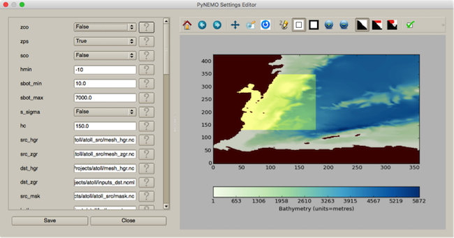
Figure 1: The toolbox GUI allows the users to define the regional ocean domain using a variety of criteria.
To run a regional ocean model, external data at the edges of the domain are required in order to obtain information about conditions that may influence the simulation e.g. temperatures, currents etc. These data are generally provided from global ocean or climate simulations. The NRCT provides access to remote datasets such as the climate model databases from the Coupled Model Intercomparison Project (CMIP3 and CMIP5), which have been used in recent reports by the Intergovernmental Panel of Climate Change (IPCC). The NRCT effectively translates data from a parent model source (a global or climate simulation) into a format suitable to run a regional NEMO ocean simulation. The ability to access external remote datasets no matter where they may be held removes the need for a multi-step process of transferring and pre-processing data on multiple systems (e.g. in-house clusters or local workstations) before running the final code on ARCHER.
This toolbox will not only benefit those employing it on ARCHER, but also the wider NEMO community as a whole (500+ users globally). It will provide tractability/traceability to the process and allow rapid deployment for regional ocean simulations (Figure 2) to provide timely scientific output.
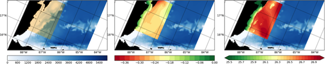
Figure 2: a) Selection of a region using the Nemo Regional Configuration Toolbox; b) & c) the results of sea surface height (metres) and temperature (degrees C) from the subsequent simulations
Summary of the software
The Nemo Regional Configuration Toolbox has been developed from existing
proprietary ad-hoc code, improving the flexibility of the tool,
especially in terms of the IO. With portability and sustainability in
mind, the tool is written in Python, largely within the Anaconda
environment:
https://store.continuum.io/cshop/anaconda/.
An overview of the software, its installation and examples of usage are
provided at:
http://pynemo.readthedocs.org/en/latest/intro.html.
As it has been written with the Anaconda environment in mind, the software can be installed on ARCHER using conda install, or built from source. At present it is advisable to build from source, as the code is still being actively developed and the builds used in the conda install process may be dated.
On ARCHER users can access the toolbox using the Anaconda environment as follows:
module add anaconda
conda install -c
https://conda.anaconda.org/srikanthnagella pynemo
From source:
svn checkout http://ccpforge.cse.rl.ac.uk/svn/pynemo/trunk/Python/
conda install -c https://conda.anaconda.org/srikanthnagella
thredds_crawler
conda install -c
https://conda.anaconda.org/srikanthnagella pyjnius
python setup.py
install
The tool essentially uses geographical and depth information from the source data (e.g. a global ocean simulation) and destination simulation (i.e. the proposed regional NEMO model configuration) to determine which source points are required for data extraction. This is done using a kdtree approximate nearest neighbour algorithm. The idea behind this targeted method is that it provides a generic method of interpolation for any flavour of ocean model in order to set up a regional NEMO model configuration. Various options are accessed either through a NEMO style namelist or a convenient GUI. The IO abstraction in the toolbox allows the user to simply define where the relevant datasets are held and the variables required without the need to understand the methods used to read or write the data, be it local or held on a remote server.